60-Unit Building Proposed for Flood-Prone, Congested Mamaroneck Avenue
- Mamaroneck Observer
- Feb 25
- 4 min read


by Meg Yergin -
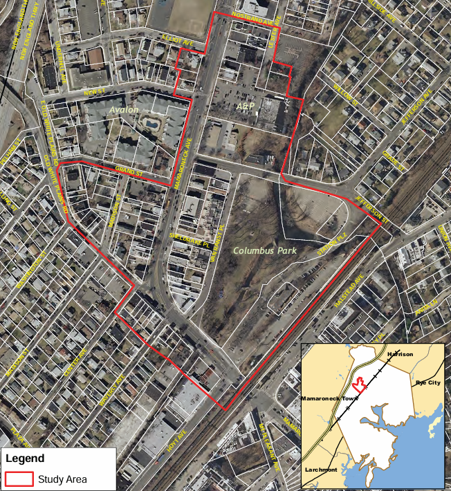
A 60-unit mixed-use development is proposed for the former site of Bilotta Kitchen & Home at 526 Mamaroneck Avenue — a stretch of roadway associated with traffic congestion and flooding. The developer plans to combine four lots across from Columbus Park and the Metro-North train station to construct a four-story building with ground-floor retail and three floors of apartments above.
The project would represent a substantial densification of the block as the proposed building would be 50 percent larger than the maximum allowed under the Code without a variance.

The Planning Board (PB) initiated its preliminary review of the project on February 11.
How Much Is Too Much for Mamaroneck Avenue?
This section of Mamaroneck Avenue, located within the Village’s Transit Overlay District (TOD), carries nearly 19,000 vehicles per day See HERE and more than 400 pedestrians during peak hours. See HERE. It serves Metro-North commuters, motorists entering and exiting I-95, children and parents on their way to Mamaroneck Avenue School, and residents of an increasing number of multifamily buildings.
The TOD was adopted to encourage higher-density, mixed-use development within walking distance of the train station with the expectation that residents would need fewer cars. In this overlay district, developers may build taller structures with reduced parking requirements without the need for variances.
Since its creation in 2014, numerous new residential and retail projects have reshaped the area, and it has become well known for traffic gridlock and pedestrian issues. The PB will have to evaluate how this new development would impact traffic conditions and pedestrian safety as part of its review.
Heightened Pedestrian Safety Concerns
Pedestrian safety remains a sensitive issue along this corridor. In 2021, a pedestrian was killed in a hit-and-run accident just yards from the proposed project site. See HERE. In 2024, a mother and child were tragically killed by a school bus while crossing at the New Street intersection. See HERE.
Those horrific events have brought community focus on traffic patterns and crosswalk safety in the immediate vicinity.
Flood Risks and Pressure on First Responders
Flooding is another issue for this location adjacent to the Sheldrake River. This FEMA special flood hazard area has been repeatedly ravaged by significant flood events including Tropical Storm Ida in 2021. Bilotta Kitchen & Home moved out of the area after experiencing extensive flood damage in that storm.
The flooding from Ida was so severe that it prompted emergency evacuations of residents trapped in their homes. See HERE. Flooding in October 2023 also resulted in emergency evacuations.

A 60-unit residential building would add dozens of new residents to the area, potentially increasing the stress on the capacity of emergency responders during severe storms.
Is the Project Flood-Zone Compliant?
Because the Village participates in the National Flood Insurance Program, new construction in special flood hazard areas must meet or exceed FEMA standards and obtain a Floodplain Development Permit. See HERE. The project’s required application for that permit — which would detail its flood-zone compliance — does not appear in the PB’s online meeting materials, and it is unclear if the project meets FEMA requirements.
In special flood hazard areas, FEMA requires the lowest residential floor of a mixed-use building to be constructed at or above the Base Flood Elevation (BFE), which is 26 feet in this zone. Non-residential spaces used for retail or parking may be built below BFE if properly dry-proofed. See HERE.
BFE is the elevation that FEMA has calculated to be the height floodwaters have a 1% chance of reaching in any given year. But floods reaching lesser elevations can and do occur frequently in special flood hazard zones.
Questions About Ground Fill
The project’s site plans show three-foot retaining walls on either side of the building, suggesting fill may be used to elevate the structure to meet BFE requirements. FEMA warns that the use of fill in flood-prone areas can increase stormwater runoff and floodwater displacement, potentially worsening flooding on neighboring properties and streets. See HERE.
Building Is More Than 50% Larger Than Code Allows
In addition to the PB’s review, the proposal will require reviews by other land use boards. These include requests for area variances by the Zoning Board of Appeals, including:
· A 50.56% floor area ratio (FAR) variance, as the building is designed to be 1.5 times larger than allowed by Code. (The applicant plans to claim a TOD 3% FAR bonus by including a full-service grocery store in its retail uses.) See HERE.
· A second variance because the new combined lot will exceed the Code’s maximum allowed lot size by more than 10%.
· A parking variance, as the project falls seven spaces short despite the TOD’s already reduced parking requirements.
What’s Next?
In reviewing this application, the question before the land use boards is not just whether the project complies with zoning requirements, but also whether this block — already strained by traffic and vulnerable to significant flooding — can responsibly absorb 60 more units without negatively impacting residents’ safety and quality of life.
The PB determined at the meeting that this application is a Type I action under the State Environmental Quality Review Act (SEQRA). Type I actions are defined in SEQRA regulations as actions that are significant because they are presumed to have negative environmental impacts and most likely require an Environmental Impact Statement. See HERE.
Currently the application is not listed on any published land use meeting agenda for further review.